
Rocester topographic map
Click on the map to display elevation.
About this map
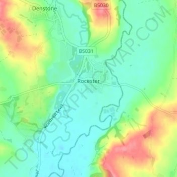
Name: Rocester topographic map, elevation, terrain.
Average elevation: 105 m
Minimum elevation: 79 m
Maximum elevation: 156 m
Staffordshire trails, hiking, mountain biking, running and outdoor activities
Other topographic maps
Click on a map to view its topography, its elevation and its terrain.
Burton upon Trent
United Kingdom > England > Staffordshire > East Staffordshire
Burton is about 109 miles (175 km) north west of London, about 30 miles north east of Birmingham, the UK's second largest city and about 23 miles east of the county town Stafford. It is at the easternmost border of the county of Staffordshire with Derbyshire, its suburbs and the course of the River Trent…
Average elevation: 69 m
Tutbury Castle
United Kingdom > England > Staffordshire > East Staffordshire > Tutbury
Average elevation: 66 m
Stubwood
United Kingdom > England > Staffordshire > East Staffordshire > Denstone
Average elevation: 113 m
Birch Cross
United Kingdom > England > Staffordshire > East Staffordshire > Marchington
Average elevation: 92 m
Blithfield Reservoir
United Kingdom > England > Staffordshire > East Staffordshire > Admaston
Average elevation: 108 m
Gratwich
United Kingdom > England > Staffordshire > East Staffordshire > Kingstone
Average elevation: 143 m
Marchington Woodlands
United Kingdom > England > Staffordshire > East Staffordshire
Average elevation: 120 m
Harlow Wood
United Kingdom > England > Staffordshire > East Staffordshire > Upper Mayfield
Average elevation: 177 m
Burton upon Trent
United Kingdom > England > Staffordshire > East Staffordshire
Burton is about 109 miles (175 km) north west of London, about 30 miles north east of Birmingham, the UK's second largest city and about 23 miles east of the county town Stafford. It is at the easternmost border of the county of Staffordshire with Derbyshire, its suburbs and the course of the River Trent…
Average elevation: 69 m