
Bramshall topographic map
Click on the map to display elevation.
About this map
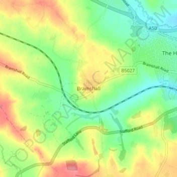
Name: Bramshall topographic map, elevation, terrain.
Average elevation: 121 m
Minimum elevation: 86 m
Maximum elevation: 165 m
Staffordshire trails, hiking, mountain biking, running and outdoor activities
Other topographic maps
Click on a map to view its topography, its elevation and its terrain.
Tutbury Castle
United Kingdom > England > Staffordshire > East Staffordshire > Tutbury
Average elevation: 66 m
Barton-under-Needwood
United Kingdom > England > Staffordshire > East Staffordshire > Barton-under-Needwood
Average elevation: 69 m
Draycott in the Clay
United Kingdom > England > Staffordshire > East Staffordshire
Average elevation: 90 m
Blithfield Reservoir
United Kingdom > England > Staffordshire > East Staffordshire > Admaston
Average elevation: 108 m
Shobnall
United Kingdom > England > Staffordshire > East Staffordshire > Burton-on-Trent
Average elevation: 56 m
Mayfield
United Kingdom > England > Staffordshire > East Staffordshire > Mayfield
Average elevation: 156 m
Hanbury
United Kingdom > England > Staffordshire > East Staffordshire
This locality adjoins the River Dove and includes a steep knoll between much of it and the river, Row Hill; five listed buildings are here all at Grade II. Hanbury's village centre is 0.9 miles (1.4 km) to the south. This hamlet is at an elevation of 61m AOD whereas the village centre of Hanbury is at the…
Average elevation: 107 m
Harlow Wood
United Kingdom > England > Staffordshire > East Staffordshire > Upper Mayfield
Average elevation: 177 m