
16055 topographic map
Interactive map
Click on the map to display elevation.
About this map
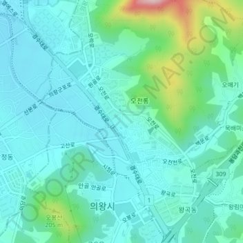
Name: 16055 topographic map, elevation, terrain.
Location: 16055, Ojeon-dong, Uiwang-si, Gyeonggi, South Korea (37.35419 126.97165 37.35429 126.97175)
Average elevation: 95 m
Minimum elevation: 37 m
Maximum elevation: 341 m
Other topographic maps
Click on a map to view its topography, its elevation and its terrain.