
San Pedro Columbia topographic map
Interactive map
Click on the map to display elevation.
About this map
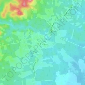
Name: San Pedro Columbia topographic map, elevation, terrain.
Location: San Pedro Columbia, Toledo District, Belize (16.25024 -88.97432 16.29024 -88.93432)
Average elevation: 29 m
Minimum elevation: 7 m
Maximum elevation: 113 m
Other topographic maps
Click on a map to view its topography, its elevation and its terrain.