
Make a donation
Gear up for your next adventure:
As an Amazon Associate, this site earns from qualifying purchases at no extra cost to you.
Lake Turkana topographic map
Click on the map to display elevation.
Make a donation
Gear up for your next adventure:
As an Amazon Associate, this site earns from qualifying purchases at no extra cost to you.
Lake Turkana
The rocks of the surrounding area are predominantly volcanic. Central Island is an active volcano, emitting vapour. Outcrops and rocky shores are found on the east and south shores of the lake, while dunes, spits and flats are on the west and north, at a lower elevation.
Make a donation
Gear up for your next adventure:
As an Amazon Associate, this site earns from qualifying purchases at no extra cost to you.
About this map
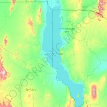
Name: Lake Turkana topographic map, elevation, terrain.
Location: Lake Turkana, Marsabit County, Eastern, Kenya (2.39737 35.82914 4.65387 36.70775)
Average elevation: 590 m
Minimum elevation: 358 m
Maximum elevation: 2,270 m
Make a donation
Gear up for your next adventure:
As an Amazon Associate, this site earns from qualifying purchases at no extra cost to you.
Other topographic maps
Click on a map to view its topography, its elevation and its terrain.
Make a donation
Gear up for your next adventure:
As an Amazon Associate, this site earns from qualifying purchases at no extra cost to you.
Make a donation
Gear up for your next adventure:
As an Amazon Associate, this site earns from qualifying purchases at no extra cost to you.
Make a donation
Gear up for your next adventure:
As an Amazon Associate, this site earns from qualifying purchases at no extra cost to you.