
Tengeru topographic map
Interactive map
Click on the map to display elevation.
About this map
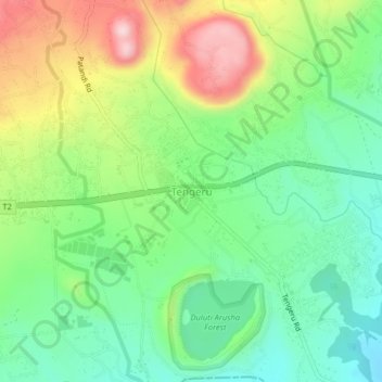
Name: Tengeru topographic map, elevation, terrain.
Location: Tengeru, Meru, Arusha, Northern Zone, Tanzania (-3.39334 36.76602 -3.35334 36.80602)
Average elevation: 1,317 m
Minimum elevation: 1,203 m
Maximum elevation: 1,512 m
Other topographic maps
Click on a map to view its topography, its elevation and its terrain.
Makao Mapya
Tanzania > Arusha > Makao Mapya
Makao Mapya, Arumeru, Arusha, Northern Zone, Tanzania
Average elevation: 911 m