
Tannenboden topographic map
Interactive map
Click on the map to display elevation.
About this map
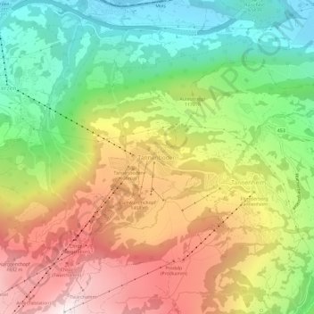
Name: Tannenboden topographic map, elevation, terrain.
Average elevation: 1,102 m
Minimum elevation: 422 m
Maximum elevation: 1,933 m
Other topographic maps
Click on a map to view its topography, its elevation and its terrain.
Pizol
Schweiz > Sankt Gallen > Wahlkreis Sarganserland > Mels
Pizol, Mels, Wahlkreis Sarganserland, Sankt Gallen, Schweiz
Average elevation: 2,439 m
Flums
Schweiz > Sankt Gallen > Wahlkreis Sarganserland
Flums, Wahlkreis Sarganserland, Sankt Gallen, Schweiz
Average elevation: 1,328 m
Vermol
Schweiz > Sankt Gallen > Wahlkreis Sarganserland > Mels > Vermol
Vermol, Mels, Wahlkreis Sarganserland, Sankt Gallen, 8886, Schweiz
Average elevation: 1,054 m
Walenstadtberg
Schweiz > Sankt Gallen > Wahlkreis Sarganserland > Walenstadt > Walenstadtberg
Walenstadtberg, Walenstadt, Wahlkreis Sarganserland, Sankt Gallen, 8881, Schweiz
Average elevation: 1,064 m
St. Leonhard
Schweiz > Sankt Gallen > Wahlkreis Sarganserland > Bad Ragaz > St. Leonhard
St. Leonhard, Bad Ragaz, Wahlkreis Sarganserland, Sankt Gallen, 7310, Schweiz
Average elevation: 633 m