
Osorno Volcano topographic map
Interactive map
Click on the map to display elevation.
About this map
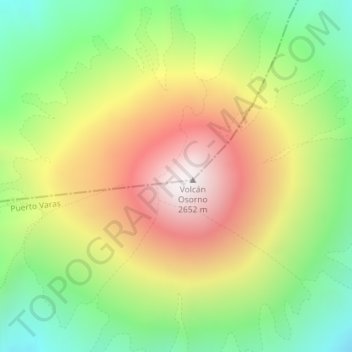
Name: Osorno Volcano topographic map, elevation, terrain.
Average elevation: 1,994 m
Minimum elevation: 1,368 m
Maximum elevation: 2,661 m
The basalt and andesite lava flows generated during these eruptions reached both Lago Llanquihue and Lago Todos Los Santos. The upper slopes of the volcano are almost entirely covered in glaciers despite its very modest altitude and latitude, sustained by the substantial annual snowfall in the very moist maritime climate of the region. Osorno has also historically produced pyroclastic flow, since it is a composite volcano. The volcano has been noted for its similar appearance to Mount Fuji in Japan.
Other topographic maps
Click on a map to view its topography, its elevation and its terrain.
Nueva Braunau
Chile > Los Lagos Region > Provincia de Llanquihue > Puerto Varas
Nueva Braunau, Puerto Varas, Provincia de Llanquihue, Los Lagos Region, Chile
Average elevation: 105 m
Volcán Calbuco
Chile > Los Lagos Region > Provincia de Llanquihue > Puerto Varas
Volcán Calbuco, Puerto Varas, Provincia de Llanquihue, Los Lagos Region, Chile
Average elevation: 1,581 m