Geolocate

Hammond topographic map

Click on the map to display elevation.

About this map
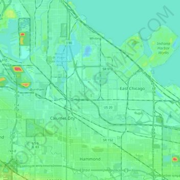
Name: Hammond topographic map, elevation, terrain.

Location: Hammond, North Township, Lake County, Indiana, United States (41.56637 -87.52539 41.71010 -87.43236)

Average elevation: 181 m

Minimum elevation: 145 m

Maximum elevation: 227 m

Other topographic maps

Click on a map to view its topography, its elevation and its terrain.

Cook

United States > Indiana > Lake County > Cedar Lake

Average elevation: 222 m

Ross

United States > Indiana > Lake County

Average elevation: 194 m

Miller

United States > Indiana > Lake County > Gary > Miller

Average elevation: 186 m

Lake Seven

United States > Indiana > Lake County > Crown Point

Average elevation: 220 m

Liverpool

United States > Indiana > Lake County > Lake Station

Average elevation: 191 m

Triangle Parkway

United States > Indiana > Lake County > Hammond

Average elevation: 184 m

Illinoi

United States > Indiana > Lake County

Average elevation: 192 m

Glen Park

United States > Indiana > Lake County > Gary

Average elevation: 193 m

Gear up for your next adventure:

⌚GPS Outdoor Watches - Watches with GPS tracking for hiking and exploration
🛰️Outdoor GPS Navigation - Navigation devices for remote and off-grid areas
🧥Breathable Waterproof Jackets - Essential rain protection for the unpredictable British climate
🛌Sleeping Mats - Insulated mats for comfortable outdoor sleeping
🛌Sleeping Bags - Warm and packable sleeping bags for outdoor nights

As an Amazon Associate, this site earns from qualifying purchases at no extra cost to you.