
住之江区 topographic map
Interactive map
Click on the map to display elevation.
About this map
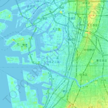
Name: 住之江区 topographic map, elevation, terrain.
Location: 住之江区, 大阪市, 大阪府, 日本 (34.59601 135.34642 34.64899 135.49284)
Average elevation: 6 m
Minimum elevation: -12 m
Maximum elevation: 43 m
上町台地の西側に広がり、平坦な地形となっている。古代は地域の大半が海だったが、大阪湾の沖積活動により砂州が形成され、陸地化が進んでいったと考えられる。古代の海岸線は現在の阪堺電気軌道阪堺線付近、中世の海岸線は現在の阪神高速15号堺線付近と考えられている。江戸時代の新田開発、明治時代以降の埋め立てによって、現在の陸地が形成されている。
Other topographic maps
Click on a map to view its topography, its elevation and its terrain.