
Dendi topographic map
Interactive map
Click on the map to display elevation.
About this map
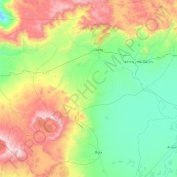
Name: Dendi topographic map, elevation, terrain.
Location: Dendi, West Shewa, Oromia, Éthiopie (8.71523 37.91485 9.15387 38.34214)
Average elevation: 2,441 m
Minimum elevation: 1,975 m
Maximum elevation: 3,305 m
Other topographic maps
Click on a map to view its topography, its elevation and its terrain.
Ililan Goro
Ililan Goro, Dendi, West Shewa, Oromia, Éthiopie
Average elevation: 2,795 m