Geolocate

Dinas topographic map

Click on the map to display elevation.

About this map

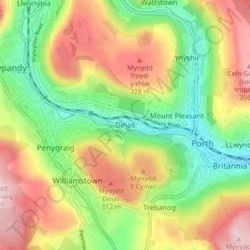
Name: Dinas topographic map, elevation, terrain.

Location: Dinas, Rhondda Cynon Taf, Wales, CF40 1JG, United Kingdom (51.59546 -3.44841 51.63546 -3.40841)

Average elevation: 221 m

Minimum elevation: 87 m

Maximum elevation: 381 m

Rhondda Cynon Taf trails, hiking, mountain biking, running and outdoor activities

Other topographic maps

Click on a map to view its topography, its elevation and its terrain.

Mid Glamorgan

United Kingdom > Wales > Rhondda Cynon Taf

Average elevation: 235 m

Pontypridd

United Kingdom > Wales > Rhondda Cynon Taf

Average elevation: 183 m

Penrhiwceiber

United Kingdom > Wales > Rhondda Cynon Taf

Average elevation: 229 m

Pontypridd

United Kingdom > Wales > Rhondda Cynon Taf

Average elevation: 183 m

Trealaw

United Kingdom > Wales > Rhondda Cynon Taf > Tonypandy

Average elevation: 222 m

Gear up for your next adventure:

🕶️Polarized Sunglasses - Reduces glare from snow and water when reading terrain
🧦Merino Wool Hiking Socks - Moisture-wicking socks to prevent blisters during long mountain walks
🥼Base Layers - Thermal base layers for temperature regulation
🎒Hiking Daypacks - Compact backpacks ideal for short hikes and excursions
🔦Outdoor Torches - Reliable torches for night navigation

As an Amazon Associate, this site earns from qualifying purchases at no extra cost to you.