Geolocate

Torpo topographic map

Click on the map to display elevation.

About this map

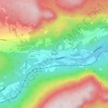
Name: Torpo topographic map, elevation, terrain.

Location: Torpo, Ål, Buskerud, 3579, Norway (60.64452 8.69940 60.68452 8.73940)

Average elevation: 543 m

Minimum elevation: 301 m

Maximum elevation: 861 m

Other topographic maps

Click on a map to view its topography, its elevation and its terrain.

Kongsberg

Norway > Buskerud

Average elevation: 388 m

Norefjell

Norway > Buskerud

Average elevation: 758 m

Flå

Norway > Buskerud

Average elevation: 719 m

Hemsedal

Norway > Buskerud

Average elevation: 1,217 m

Hemsedal

Norway > Buskerud

Average elevation: 1,217 m

Hol

Norway > Buskerud

Average elevation: 1,204 m

Hemsedal

Norway > Buskerud

Average elevation: 1,217 m

Ringerike

Norway > Buskerud

Average elevation: 443 m

Flesberg

Norway > Buskerud

Average elevation: 520 m

Ål

Norway > Buskerud

The Bergen Line, the rail line between Oslo and Bergen runs through Ål. Ål Station has an elevation of 436 meters (1,430 ft) and is the halfway station on the Bergen Line.

Average elevation: 1,023 m

Flesberg

Norway > Buskerud

Average elevation: 520 m

Hemsedal

Norway > Buskerud

Average elevation: 1,217 m

Hole

Norway > Buskerud

Average elevation: 266 m

Drammen

Norway > Buskerud

Average elevation: 209 m

Nesbyen

Norway > Buskerud

Average elevation: 842 m

Gear up for your next adventure:

🧤Thermal Touchscreen Gloves - Stay warm while operating your GPS or smartphone camera
🔪Outdoor Multi-Tools - Versatile tools for gear repairs and food prep in the wild
🛑Emergency Bivvy Bags - Heat-reflective survival bags for unexpected nights out
❄️Walking Crampons - Added traction for icy slopes and winter peak bagging
🦯Walking Poles - Supportive poles for long-distance walking

As an Amazon Associate, this site earns from qualifying purchases at no extra cost to you.