Geolocate

Calvert Cliffs topographic map

Click on the map to display elevation.

About this map

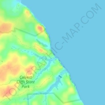
Name: Calvert Cliffs topographic map, elevation, terrain.

Location: Calvert Cliffs, Calvert County, Maryland, 20657, United States (38.40712 -76.41364 38.40874 -76.41226)

Average elevation: 11 m

Minimum elevation: 0 m

Maximum elevation: 41 m

Other topographic maps

Click on a map to view its topography, its elevation and its terrain.

Owings

United States > Maryland > Calvert County > Owings

Average elevation: 35 m

Sandy Bottom

United States > Maryland > Calvert County

Average elevation: 35 m

Huntingtown

United States > Maryland > Calvert County

Average elevation: 32 m

Huntingtown

United States > Maryland > Calvert County

Average elevation: 32 m

Fox Den

United States > Maryland > Calvert County

Average elevation: 18 m

Lusby

United States > Maryland > Calvert County > Lusby

Average elevation: 19 m

Solomons

United States > Maryland > Calvert County > Solomons

Average elevation: 4 m

Hickory Hills

United States > Maryland > Calvert County

Average elevation: 25 m

Lusby

United States > Maryland > Calvert County

Average elevation: 26 m

Lusby

United States > Maryland > Calvert County

Average elevation: 25 m

Ravenshead

United States > Maryland > Calvert County

Average elevation: 22 m

Solomons

United States > Maryland > Calvert County

Average elevation: 9 m

Gear up for your next adventure:

🛌Sleeping Mats - Insulated mats for comfortable outdoor sleeping
🦯Walking Poles - Supportive poles for long-distance walking
🧗Locking Carabiners - Secure gear to your pack or for light technical use
🔦Keychain LED Torches - Emergency backup light for finding gear in your pack
📦Dry Bags - Waterproof bags to protect gear from rain

As an Amazon Associate, this site earns from qualifying purchases at no extra cost to you.