Geolocate

Krasnobród topographic map

Interactive map

Click on the map to display elevation.

About this map

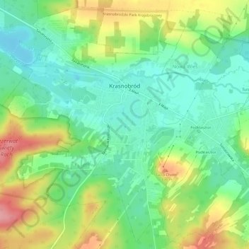
Name: Krasnobród topographic map, elevation, terrain.

Location: Krasnobród, gmina Krasnobród, Zamość County, Lublin Voivodeship, 22-440, Poland (50.52329 23.18364 50.55744 23.24039)

Average elevation: 285 m

Minimum elevation: 243 m

Maximum elevation: 357 m

Other topographic maps

Click on a map to view its topography, its elevation and its terrain.

Kornelówka

Poland > Lublin Voivodeship > Zamość County

Kornelówka, gmina Sitno, Zamość County, Lublin Voivodeship, Poland

Average elevation: 244 m

Janówka Wschodnia

Poland > Lublin Voivodeship > Zamość County

Janówka Wschodnia, gmina Komarów-Osada, Zamość County, Lublin Voivodeship, Poland

Average elevation: 267 m

Białobrzegi

Poland > Lublin Voivodeship > Zamość County

Białobrzegi, gmina Zamość, Zamość County, Lublin Voivodeship, Poland

Average elevation: 209 m