
Rombon topographic map
Interactive map
Click on the map to display elevation.
About this map
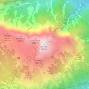
Name: Rombon topographic map, elevation, terrain.
Location: Rombon, Bovec, Goriška, 5230, Slovénie (46.36725 13.55435 46.36735 13.55445)
Average elevation: 1,465 m
Minimum elevation: 679 m
Maximum elevation: 2,201 m
Other topographic maps
Click on a map to view its topography, its elevation and its terrain.