
Trenta topographic map
Interactive map
Click on the map to display elevation.
About this map
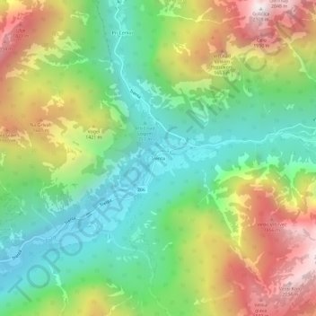
Name: Trenta topographic map, elevation, terrain.
Location: Trenta, Bovec, 5232, Slovénie (46.36084 13.73192 46.40084 13.77192)
Average elevation: 1,150 m
Minimum elevation: 557 m
Maximum elevation: 2,084 m
Other topographic maps
Click on a map to view its topography, its elevation and its terrain.