
Make a donation
Gear up for your next adventure:
As an Amazon Associate, this site earns from qualifying purchases at no extra cost to you.
Chongqing topographic map
Click on the map to display elevation.
Make a donation
Gear up for your next adventure:
As an Amazon Associate, this site earns from qualifying purchases at no extra cost to you.
Chongqing
The central urban area of Chongqing, or Chongqing proper, is a city of unique features. Built on mountains and partially surrounded by the Yangtze and Jialing rivers, it is known as a "mountain city" and a "city on rivers". The night scene of the city is very illuminated, with millions of lights and their reflection on the rivers. With its special topographical features, Chongqing has the unique scenery of mountains, rivers, forests, springs, waterfalls, gorges, and caves. Li Bai, a famous poet of the Tang dynasty, was inspired by the natural scenery and wrote this epigram.
Make a donation
Gear up for your next adventure:
As an Amazon Associate, this site earns from qualifying purchases at no extra cost to you.
About this map
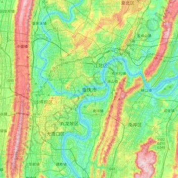
Name: Chongqing topographic map, elevation, terrain.
Location: Chongqing, Yuzhong District, Chongqing, 400014, China (29.40567 106.38792 29.72567 106.70792)
Average elevation: 318 m
Minimum elevation: 148 m
Maximum elevation: 681 m
Make a donation
Gear up for your next adventure:
As an Amazon Associate, this site earns from qualifying purchases at no extra cost to you.
Other topographic maps
Click on a map to view its topography, its elevation and its terrain.
Make a donation
Gear up for your next adventure:
As an Amazon Associate, this site earns from qualifying purchases at no extra cost to you.
Banan District
Banan, situated in the southern part of the Sichuan Basin, has a diversity of terrains including mountains, hills, wetlands and flood beds. The lowest point of the district is on its northern border with Nan'an District, at an altitude of 154 meters. The highest point is the top of Fangdou Mountain in the…
Average elevation: 445 m
Make a donation
Gear up for your next adventure:
As an Amazon Associate, this site earns from qualifying purchases at no extra cost to you.
Wanzhou
Wanzhou spans 30°24′−31°14′ N latitude and 107°55′−108°53′ E longitude, and is situated at the eastern edge of the Sichuan Basin. It reaches a maximal north–south extent of 67.25 km (41.79 mi) and east–west width of 97.25 km (60.43 mi), covering an area of 3,214 km2 (1,241 sq mi).…
Average elevation: 651 m
Make a donation
Gear up for your next adventure:
As an Amazon Associate, this site earns from qualifying purchases at no extra cost to you.
Make a donation
Gear up for your next adventure:
As an Amazon Associate, this site earns from qualifying purchases at no extra cost to you.
Jiangjin District
Jiangjin lies within central China at 105°49′—106°38′of longitude and 28°28′—29°28′of north latitude. The landscape and topography of Jiangjin slopes from high elevations in the south and low in the north. Luohuangzhongba stands at the lowest elevation (178.5 m). The highest site, Wugongba in…
Average elevation: 521 m
Make a donation
Gear up for your next adventure:
As an Amazon Associate, this site earns from qualifying purchases at no extra cost to you.
Make a donation
Gear up for your next adventure:
As an Amazon Associate, this site earns from qualifying purchases at no extra cost to you.
Pengshui Miao and Tujia Autonomous County
China > Chongqing > Pengshui Miao and Tujia Autonomous County
Average elevation: 926 m
Make a donation
Gear up for your next adventure:
As an Amazon Associate, this site earns from qualifying purchases at no extra cost to you.