
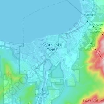
South Lake Tahoe topographic map
Interactive map
Click on the map to display elevation.
About this map
Name: South Lake Tahoe topographic map, elevation, terrain.
Average elevation: 1,979 m
Minimum elevation: 1,897 m
Maximum elevation: 2,680 m
According to the United States Census Bureau, the city has a total area of 16.6 square miles (43 km2), of which 10.2 square miles (26 km2) is land and 6.4 square miles (17 km2), or 38.80%, is water. Its elevation is about 6,237 feet (1,901 m) above sea level.
Other topographic maps
Click on a map to view its topography, its elevation and its terrain.
Motor City
United States > California > El Dorado County
Motor City, El Dorado County, California, 95709, United States
Average elevation: 747 m
Cool
United States > California > El Dorado County
Cool, El Dorado County, California, 95614, United States
Average elevation: 455 m
Diamond Springs
United States > California > El Dorado County
Diamond Springs, El Dorado County, California, 95619, United States
Average elevation: 531 m
Eldorado National Forest
United States > California > El Dorado County
Eldorado National Forest, El Dorado County, CAL Fire Northern Region, California, United States
Average elevation: 1,807 m
Cameron Park
United States > California > El Dorado County > Cameron Park
Cameron Park, El Dorado County, CAL Fire Northern Region, California, United States
Average elevation: 409 m
Shingle Springs
United States > California > El Dorado County
Shingle Springs, El Dorado County, California, 95682, United States
Average elevation: 433 m
Kyburz
United States > California > El Dorado County
Kyburz, El Dorado County, California, 95720, United States
Average elevation: 1,541 m
El Dorado Hills
United States > California > El Dorado County > Folsom
El Dorado Hills, Folsom, El Dorado County, California, 95762, United States
Average elevation: 254 m
El Dorado Hills
United States > California > El Dorado County > Folsom
El Dorado Hills, Folsom, El Dorado County, CAL Fire Northern Region, California, 95762, United States
Average elevation: 243 m
Pollock Pines
United States > California > El Dorado County > Pollock Pines
Pollock Pines, El Dorado County, California, 95726, United States
Average elevation: 1,118 m
Stumpy Meadows Reservoir
United States > California > El Dorado County
Stumpy Meadows Reservoir, El Dorado County, California, United States
Average elevation: 1,334 m
Grizzly Flat
United States > California > El Dorado County > Grizzly Flat
Grizzly Flat, El Dorado County, California, 95636, United States
Average elevation: 1,185 m
Coloma
United States > California > El Dorado County > Coloma
Coloma, El Dorado County, California, 95613, United States
Average elevation: 341 m
Placerville
United States > California > El Dorado County
Placerville, El Dorado County, California, 95667, United States
Average elevation: 586 m