
Niederanven topographic map
Interactive map
Click on the map to display elevation.
About this map
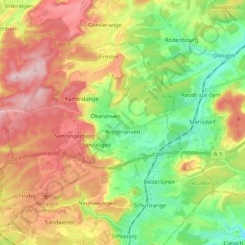
Name: Niederanven topographic map, elevation, terrain.
Location: Niederanven, Canton Luxembourg, Luxembourg (49.62298 6.14271 49.68629 6.28960)
Average elevation: 321 m
Minimum elevation: 218 m
Maximum elevation: 444 m
Other topographic maps
Click on a map to view its topography, its elevation and its terrain.
Luxembourg City: Old Quarters & Fortifications
Luxembourg > Canton Luxembourg > Luxembourg
Average elevation: 294 m