
Herberts topographic map
Interactive map
Click on the map to display elevation.
About this map
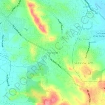
Name: Herberts topographic map, elevation, terrain.
Location: Herberts, Saint John, Antigua, Antigua and Barbuda (17.07395 -61.83611 17.11395 -61.79611)
Average elevation: 37 m
Minimum elevation: 1 m
Maximum elevation: 108 m
Other topographic maps
Click on a map to view its topography, its elevation and its terrain.
All Saints
All Saints, Saint John, Antigua, Antigua and Barbuda
Average elevation: 65 m
Boggy Peak
Antigua and Barbuda > Antigua > Bolans
Boggy Peak, Bolans, Saint Mary, Antigua, Antigua and Barbuda
Average elevation: 166 m
St. John's
St. John's, Saint John, Antigua, Antigua and Barbuda
Average elevation: 23 m
Grace Bay
Antigua and Barbuda > Antigua > Old Road
Grace Bay, Old Road, Antigua, Antigua and Barbuda
Average elevation: 17 m