
Sagnarigu Municipal District topographic map
Interactive map
Click on the map to display elevation.
About this map
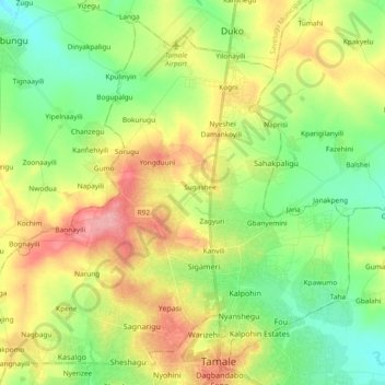
Name: Sagnarigu Municipal District topographic map, elevation, terrain.
Location: Sagnarigu Municipal District, Northern Region, Ghana (9.40352 -0.96573 9.56853 -0.77886)
Average elevation: 161 m
Minimum elevation: 121 m
Maximum elevation: 219 m
Other topographic maps
Click on a map to view its topography, its elevation and its terrain.
Pong Tamale
Ghana > Northern Region > Savelugu Municipal District
Pong Tamale, Savelugu Municipal District, Northern Region, Ghana
Average elevation: 127 m
Tamale
Ghana > Northern Region > Tamale Metropolitan District
Tamale, Tamale Metropolitan District, Northern Region, Ghana
Average elevation: 151 m
Binda
Ghana > Northern Region > Nanumba South District > Binda
Binda, Nanumba South District, Northern Region, Ghana
Average elevation: 208 m
Yendi
Ghana > Northern Region > Yendi Municipal District > Yendi
Yendi, Yendi Municipal District, Northern Region, Ghana
Average elevation: 191 m
Kanjo
Ghana > Northern Region > Kanjo
Kanjo, Nanumba South District, Northern Region, Ghana
Average elevation: 179 m