
Flash topographic map
Click on the map to display elevation.
Flash
Flash is a village in the Staffordshire Moorlands and the Peak District National Park, England. At 1,519 feet (463 m) above sea level, it is the highest village in the United Kingdom (some sources claim a height of 1,531 feet (467 m) for Wanlockhead in Scotland, but a survey in 2019 showed that there are no buildings in Wanlockhead at that elevation). Flash was an early centre for Wesleyanism.
About this map
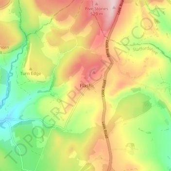
Name: Flash topographic map, elevation, terrain.
Average elevation: 412 m
Minimum elevation: 285 m
Maximum elevation: 548 m
Staffordshire trails, hiking, mountain biking, running and outdoor activities
Other topographic maps
Click on a map to view its topography, its elevation and its terrain.
Stepping Stones
United Kingdom > England > Staffordshire > Staffordshire Moorlands
Average elevation: 224 m
Cheddleton
United Kingdom > England > Staffordshire > Staffordshire Moorlands
Average elevation: 204 m
Biddulph Grange Country Park
United Kingdom > England > Staffordshire > Staffordshire Moorlands > Biddulph > Biddulph Moor
Average elevation: 229 m
Rudyard Lake
United Kingdom > England > Staffordshire > Staffordshire Moorlands > Rudyard > Horton
Average elevation: 205 m
Hales Hall Pool
United Kingdom > England > Staffordshire > Staffordshire Moorlands > Cheadle
Average elevation: 182 m
Waterhouses
United Kingdom > England > Staffordshire > Staffordshire Moorlands
Average elevation: 286 m
Draycott in the Moors
United Kingdom > England > Staffordshire > Staffordshire Moorlands
Average elevation: 177 m
Werrington
United Kingdom > England > Staffordshire > Staffordshire Moorlands
Average elevation: 218 m
Fawfieldhead
United Kingdom > England > Staffordshire > Staffordshire Moorlands
Average elevation: 311 m
Ladderedge Country Park
United Kingdom > England > Staffordshire > Staffordshire Moorlands > Leek
Average elevation: 176 m
Checkley
United Kingdom > England > Staffordshire > Staffordshire Moorlands > Checkley
Average elevation: 166 m
Dimmingsdale Valley
United Kingdom > England > Staffordshire > Staffordshire Moorlands > Alton
Average elevation: 177 m
Alton Castle
United Kingdom > England > Staffordshire > Staffordshire Moorlands > Alton
Average elevation: 154 m
Caverswall
United Kingdom > England > Staffordshire > Staffordshire Moorlands
Average elevation: 216 m
Consall
United Kingdom > England > Staffordshire > Staffordshire Moorlands > Consall
Average elevation: 216 m
Hollinsclough
United Kingdom > England > Staffordshire > Staffordshire Moorlands
Average elevation: 355 m
Alstonefield
United Kingdom > England > Staffordshire > Staffordshire Moorlands
Average elevation: 279 m
Endon Basin
United Kingdom > England > Staffordshire > Staffordshire Moorlands > Endon
Average elevation: 179 m
Werrington
United Kingdom > England > Staffordshire > Staffordshire Moorlands
Average elevation: 218 m
Caverswall
United Kingdom > England > Staffordshire > Staffordshire Moorlands
Average elevation: 216 m