
Make a donation
Gear up for your next adventure:
As an Amazon Associate, this site earns from qualifying purchases at no extra cost to you.
Ilam topographic map
Click on the map to display elevation.
Make a donation
Gear up for your next adventure:
As an Amazon Associate, this site earns from qualifying purchases at no extra cost to you.
About this map
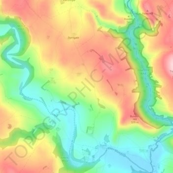
Name: Ilam topographic map, elevation, terrain.
Average elevation: 241 m
Minimum elevation: 134 m
Maximum elevation: 363 m
Staffordshire trails, hiking, mountain biking, running and outdoor activities
Make a donation
Gear up for your next adventure:
As an Amazon Associate, this site earns from qualifying purchases at no extra cost to you.
Other topographic maps
Click on a map to view its topography, its elevation and its terrain.
Werrington
United Kingdom > England > Staffordshire > Staffordshire Moorlands
Average elevation: 229 m
Biddulph Moor
United Kingdom > England > Staffordshire > Staffordshire Moorlands
Average elevation: 242 m
Stepping Stones
United Kingdom > England > Staffordshire > Staffordshire Moorlands
Average elevation: 224 m
Bottomhouse
United Kingdom > England > Staffordshire > Staffordshire Moorlands > Ipstones
Average elevation: 312 m
Make a donation
Gear up for your next adventure:
As an Amazon Associate, this site earns from qualifying purchases at no extra cost to you.
Roughcote
United Kingdom > England > Staffordshire > Staffordshire Moorlands > Caverswall
Average elevation: 217 m
Blackshaw Moor
United Kingdom > England > Staffordshire > Staffordshire Moorlands > Thorncliffe
Average elevation: 282 m
Make a donation
Gear up for your next adventure:
As an Amazon Associate, this site earns from qualifying purchases at no extra cost to you.
Horton
United Kingdom > England > Staffordshire > Staffordshire Moorlands > Gratton
Average elevation: 199 m
Merryton Low
United Kingdom > England > Staffordshire > Staffordshire Moorlands
Average elevation: 412 m
Rushton Spencer
United Kingdom > England > Staffordshire > Staffordshire Moorlands
Average elevation: 204 m
Make a donation
Gear up for your next adventure:
As an Amazon Associate, this site earns from qualifying purchases at no extra cost to you.
Wetley Rocks
United Kingdom > England > Staffordshire > Staffordshire Moorlands
Average elevation: 229 m
Old Hannah's Hole
United Kingdom > England > Staffordshire > Staffordshire Moorlands > Wetton
Average elevation: 276 m
Make a donation
Gear up for your next adventure:
As an Amazon Associate, this site earns from qualifying purchases at no extra cost to you.
Moneystone
United Kingdom > England > Staffordshire > Staffordshire Moorlands > Cotton
Average elevation: 231 m
Biddulph Grange Country Park
United Kingdom > England > Staffordshire > Staffordshire Moorlands > Biddulph > Biddulph Moor
Average elevation: 229 m
Moneystone Quarry
United Kingdom > England > Staffordshire > Staffordshire Moorlands > Kingsley > Whiston Eaves
Average elevation: 202 m
Rudyard Lake
United Kingdom > England > Staffordshire > Staffordshire Moorlands > Rudyard > Horton
Average elevation: 205 m
Make a donation
Gear up for your next adventure:
As an Amazon Associate, this site earns from qualifying purchases at no extra cost to you.
Hales Hall Pool
United Kingdom > England > Staffordshire > Staffordshire Moorlands > Cheadle
Average elevation: 182 m
Brown Edge
United Kingdom > England > Staffordshire > Staffordshire Moorlands
Average elevation: 197 m
Cellarhead
United Kingdom > England > Staffordshire > Staffordshire Moorlands
Average elevation: 240 m
Hope
United Kingdom > England > Staffordshire > Staffordshire Moorlands > Alstonefield
Average elevation: 274 m
Make a donation
Gear up for your next adventure:
As an Amazon Associate, this site earns from qualifying purchases at no extra cost to you.
Hollington
United Kingdom > England > Staffordshire > Staffordshire Moorlands
Average elevation: 151 m
Cauldon Lowe
United Kingdom > England > Staffordshire > Staffordshire Moorlands
Average elevation: 292 m
The Roaches
United Kingdom > England > Staffordshire > Staffordshire Moorlands
Average elevation: 356 m
Make a donation
Gear up for your next adventure:
As an Amazon Associate, this site earns from qualifying purchases at no extra cost to you.
Draycott Cross
United Kingdom > England > Staffordshire > Staffordshire Moorlands > Boundary
Average elevation: 183 m
Upper Tean
United Kingdom > England > Staffordshire > Staffordshire Moorlands
Average elevation: 175 m
Ladderedge Country Park
United Kingdom > England > Staffordshire > Staffordshire Moorlands > Leek
Average elevation: 176 m
Make a donation
Gear up for your next adventure:
As an Amazon Associate, this site earns from qualifying purchases at no extra cost to you.
Flash
United Kingdom > England > Staffordshire > Staffordshire Moorlands
Flash is a village in the Staffordshire Moorlands and the Peak District National Park, England. At 1,519 feet (463 m) above sea level, it is the highest village in the United Kingdom (some sources claim a height of 1,531 feet (467 m) for Wanlockhead in Scotland, but a survey in 2019 showed that there are no…
Average elevation: 412 m
CBeebies Land
United Kingdom > England > Staffordshire > Staffordshire Moorlands > Farley
Average elevation: 167 m
Dimmingsdale Valley
United Kingdom > England > Staffordshire > Staffordshire Moorlands > Alton
Average elevation: 177 m
Make a donation
Gear up for your next adventure:
As an Amazon Associate, this site earns from qualifying purchases at no extra cost to you.
Thorncliffe
United Kingdom > England > Staffordshire > Staffordshire Moorlands
Average elevation: 312 m
Alton Castle
United Kingdom > England > Staffordshire > Staffordshire Moorlands > Alton
Average elevation: 154 m
Totmonslow
United Kingdom > England > Staffordshire > Staffordshire Moorlands > Huntley
Average elevation: 170 m
Make a donation
Gear up for your next adventure:
As an Amazon Associate, this site earns from qualifying purchases at no extra cost to you.
Huntley
United Kingdom > England > Staffordshire > Staffordshire Moorlands > Huntley
Average elevation: 178 m
Endon Bank
United Kingdom > England > Staffordshire > Staffordshire Moorlands > Endon
Average elevation: 192 m
Lower Lee
United Kingdom > England > Staffordshire > Staffordshire Moorlands > Meerbrook > Lower Lee
Average elevation: 264 m
Make a donation
Gear up for your next adventure:
As an Amazon Associate, this site earns from qualifying purchases at no extra cost to you.
Thor's Cave
United Kingdom > England > Staffordshire > Staffordshire Moorlands > Grindon
Average elevation: 270 m
Endon Basin
United Kingdom > England > Staffordshire > Staffordshire Moorlands > Endon
Average elevation: 179 m
Cellarhead
United Kingdom > England > Staffordshire > Staffordshire Moorlands
Average elevation: 240 m
Make a donation
Gear up for your next adventure:
As an Amazon Associate, this site earns from qualifying purchases at no extra cost to you.