
Moat topographic map
Interactive map
Click on the map to display elevation.
About this map
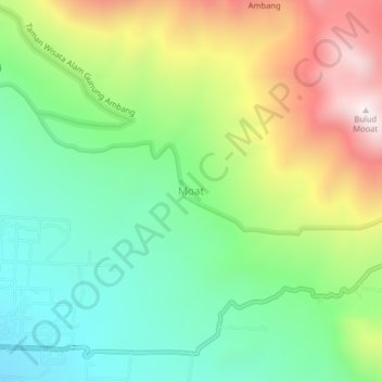
Name: Moat topographic map, elevation, terrain.
Location: Moat, Bolaang Mongondow Timur, North Sulawesi, Indonesia (0.70959 124.39230 0.74959 124.43230)
Average elevation: 961 m
Minimum elevation: 571 m
Maximum elevation: 1,616 m
Other topographic maps
Click on a map to view its topography, its elevation and its terrain.
Kotabunan
Indonesia > North Sulawesi > Bolaang Mongondow Timur
Kotabunan, Bolaang Mongondow Timur, North Sulawesi, Indonesia
Average elevation: 1 m