
Make a donation
Gear up for your next adventure:
As an Amazon Associate, this site earns from qualifying purchases at no extra cost to you.
At-Tall topographic map
Click on the map to display elevation.
Make a donation
Gear up for your next adventure:
As an Amazon Associate, this site earns from qualifying purchases at no extra cost to you.
At-Tall
Al-Tall (Arabic: التل, romanized: at-Tall, also spelled al-Tell) is a city in southern Syria, administratively part of the Rif Dimashq Governorate and capital of the al-Tall District. Situated in the middle of the Anti-Lebanon Mountains, having an elevation of roughly 1,000 meters above sea level. Nearby localities include Maaraba to the southwest, Damascus to the south, Dahiyat al-Assad and Douma to the southeast, Maarat Saidnaya to the northeast, Manin to the north, Ashrafiyat al-Wadi and Basimah to the northwest and al-Hamah and Qudsaya to the west. According to the Syria Central Bureau of Statistics (CBS), al-Tall had a population of 44,597 in the 2004 census. Its inhabitants are predominantly Sunni Muslims.
Make a donation
Gear up for your next adventure:
As an Amazon Associate, this site earns from qualifying purchases at no extra cost to you.
About this map
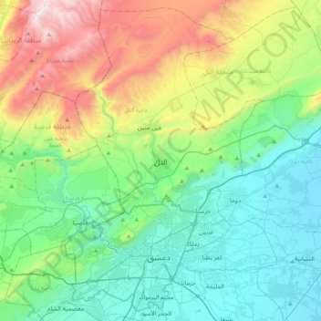
Name: At-Tall topographic map, elevation, terrain.
Average elevation: 1,037 m
Minimum elevation: 707 m
Maximum elevation: 1,442 m
Make a donation
Gear up for your next adventure:
As an Amazon Associate, this site earns from qualifying purchases at no extra cost to you.
Other topographic maps
Click on a map to view its topography, its elevation and its terrain.
Make a donation
Gear up for your next adventure:
As an Amazon Associate, this site earns from qualifying purchases at no extra cost to you.