
Thank you for supporting this site ❤️
Make a donation
Make a donation
Gear up for your next adventure:
As an Amazon Associate, this site earns from qualifying purchases at no extra cost to you.
Mangla Hamlet topographic map
Click on the map to display elevation.
Thank you for supporting this site ❤️
Make a donation
Make a donation
Gear up for your next adventure:
As an Amazon Associate, this site earns from qualifying purchases at no extra cost to you.
About this map
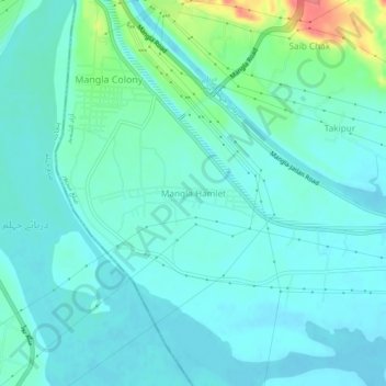
Name: Mangla Hamlet topographic map, elevation, terrain.
Location: Mangla Hamlet, Mirpur District, Azad Kashmir, Pakistan (33.08186 73.63252 33.12186 73.67252)
Average elevation: 267 m
Minimum elevation: 252 m
Maximum elevation: 330 m
Thank you for supporting this site ❤️
Make a donation
Make a donation
Gear up for your next adventure:
As an Amazon Associate, this site earns from qualifying purchases at no extra cost to you.