
Make a donation
Gear up for your next adventure:
As an Amazon Associate, this site earns from qualifying purchases at no extra cost to you.
Lumle topographic map
Click on the map to display elevation.
Make a donation
Gear up for your next adventure:
As an Amazon Associate, this site earns from qualifying purchases at no extra cost to you.
About this map
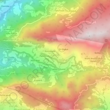
Name: Lumle topographic map, elevation, terrain.
Location: Lumle, Annapurna, Kaski, Gandaki Province, Nepal (28.27925 83.78230 28.31925 83.82230)
Average elevation: 1,663 m
Minimum elevation: 1,039 m
Maximum elevation: 2,208 m
Make a donation
Gear up for your next adventure:
As an Amazon Associate, this site earns from qualifying purchases at no extra cost to you.
Other topographic maps
Click on a map to view its topography, its elevation and its terrain.
Phewa Lake
Nepal > Gandaki Province > Kaski > Pokhara
Phewa Lake, Phewa Tal or Fewa Lake (Nepali: फेवा ताल, [ˈpʰewa tal]) is a freshwater lake in Nepal formerly called Baidam Tal located in the south of the Pokhara Valley that includes Pokhara city and parts of Sarangkot and Kaskikot. It is the second largest lake in Nepal and the largest in…
Average elevation: 884 m