
Sinnamary topographic map
Interactive map
Click on the map to display elevation.
About this map
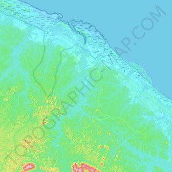
Name: Sinnamary topographic map, elevation, terrain.
Location: Sinnamary, Arrondissement de Cayenne, Guyane, 97315, France (4.98159 -53.21414 5.52761 -52.80590)
Average elevation: 31 m
Minimum elevation: -2 m
Maximum elevation: 363 m
Other topographic maps
Click on a map to view its topography, its elevation and its terrain.
Camp Saut-Pararé
Camp Saut-Pararé, Régina, Saint-Georges, Guyane, France
Average elevation: 70 m
Mont Cépérou
Mont Cépérou, Cayenne, Arrondissement de Cayenne, Guyane, 97300, France
Average elevation: 2 m
Montsinéry
France > Guyane > Montsinéry-Tonnegrande > Montsinéry
Montsinéry, Montsinéry-Tonnegrande, Cayenne, Guyane, 97356, France
Average elevation: 7 m
Remire-Montjoly
Remire-Montjoly, Cayenne, Guyane, 97354, France
Average elevation: 18 m