
Mae Tha topographic map
Interactive map
Click on the map to display elevation.
About this map
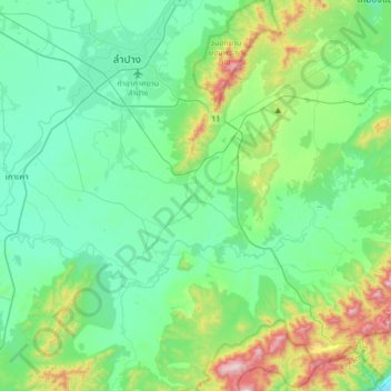
Name: Mae Tha topographic map, elevation, terrain.
Location: Mae Tha, Lampang Province, 52150, Thailand (18.01783 99.39504 18.33783 99.71504)
Average elevation: 340 m
Minimum elevation: 164 m
Maximum elevation: 973 m
Other topographic maps
Click on a map to view its topography, its elevation and its terrain.
Lampang
Lampang, Ton Thong Chai, Lampang Province, 14001, Thailand
Average elevation: 293 m
Pa Tan Na Khrua
Pa Tan Na Khrua, Lampang Province, Thailand
Average elevation: 334 m
Ngao
Thailand > Lampang Province > Ngao
Ngao, Luang Tai, Lampang Province, Thailand
Average elevation: 292 m
Ban Luang
Thailand > Lampang Province > Ban Luang
Ban Luang, Lampang Province, Thailand
Average elevation: 383 m