
النحلي topographic map
Interactive map
Click on the map to display elevation.
About this map
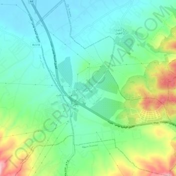
Name: النحلي topographic map, elevation, terrain.
Location: النحلي, معتمدية قلعة الأندلس, Ariana, 2094, Tunisia (36.87904 10.10474 36.92440 10.15424)
Average elevation: 68 m
Minimum elevation: 6 m
Maximum elevation: 213 m
Other topographic maps
Click on a map to view its topography, its elevation and its terrain.
أريانة العليا
أريانة العليا, معتمدية أريانة المدينة, Ariana, 2037, Tunisia
Average elevation: 66 m