
Rome Township topographic map
Interactive map
Click on the map to display elevation.
About this map
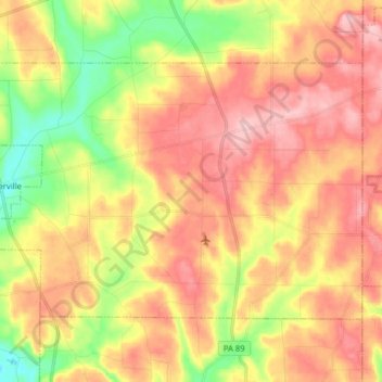
Name: Rome Township topographic map, elevation, terrain.
Location: Rome Township, Crawford County, Pennsylvania, United States (41.69472 -79.77145 41.77430 -79.61265)
Average elevation: 472 m
Minimum elevation: 380 m
Maximum elevation: 548 m
Rome Township is located in the southeastern part of Crawford County in the Northwestern Glaciated Plateau of Pennsylvania. The township is drained by Oil Creek, a southward-flowing tributary of the Allegheny River, and two tributaries to Oil Creek, East Branch Oil Creek, and tributaries of Thompson Creek. Tributaries to East Branch Oil Creek include Britton Run, Coon Run, Twomile Creek, and Fivemile Creek. Tributaries to Thompson Creek include McLaughlin Creek, Shirley Run and its tributary Dolly Run, and Hummer Creek. The lowest elevation of Rome Township is 1,260 ft (380 m), where Oil Creek flows out of the township north of Tryonville Station. The highest elevation is 1,790 ft (550 m) is located near Buells Corners, Pennsylvania.
Other topographic maps
Click on a map to view its topography, its elevation and its terrain.
Sugar Lake
United States > Pennsylvania > Crawford County
Sugar Lake, Wayne Township, Crawford County, Pennsylvania, United States
Average elevation: 428 m
Cochranton
United States > Pennsylvania > Crawford County > Cochranton
Cochranton, Crawford County, Pennsylvania, United States
Average elevation: 351 m
Spartansburg
United States > Pennsylvania > Crawford County > Spartansburg
Spartansburg, Crawford County, Pennsylvania, United States
Average elevation: 463 m
Titusville
United States > Pennsylvania > Crawford County
Titusville, Crawford County, Pennsylvania, United States
Average elevation: 419 m