
Make a donation
Gear up for your next adventure:
As an Amazon Associate, this site earns from qualifying purchases at no extra cost to you.
Janzur topographic map
Click on the map to display elevation.
Make a donation
Gear up for your next adventure:
As an Amazon Associate, this site earns from qualifying purchases at no extra cost to you.
Janzur
On March 6, 1912, the Italian forces became the first to use airships in war, as two dirigibles dropped bombs on Turkish troops and Libyan Mujahideen encamped at Janzour, from an altitude of 6,000 feet.
Make a donation
Gear up for your next adventure:
As an Amazon Associate, this site earns from qualifying purchases at no extra cost to you.
About this map
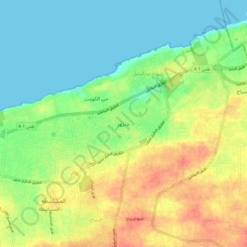
Name: Janzur topographic map, elevation, terrain.
Location: Janzur, Jafara, Libya (32.78545 12.98625 32.86545 13.06625)
Average elevation: 20 m
Minimum elevation: -1 m
Maximum elevation: 47 m
Make a donation
Gear up for your next adventure:
As an Amazon Associate, this site earns from qualifying purchases at no extra cost to you.
Other topographic maps
Click on a map to view its topography, its elevation and its terrain.