Geolocate

Antwerp topographic map

Click on the map to display elevation.

About this map

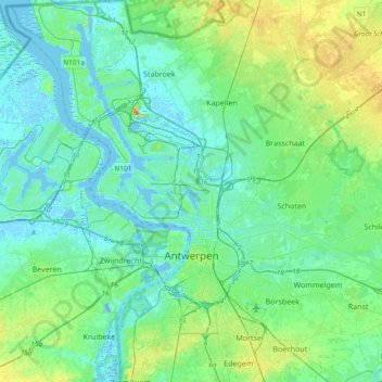
Name: Antwerp topographic map, elevation, terrain.

Location: Antwerp, Flanders, Belgium (51.14329 4.21758 51.37764 4.50905)

Average elevation: 9 m

Minimum elevation: -12 m

Maximum elevation: 38 m

Other topographic maps

Click on a map to view its topography, its elevation and its terrain.

Interescaut

Belgium > Antwerp > Antwerp > Schelle

Average elevation: 5 m

Lillo-Fort

Belgium > Antwerp > Antwerp > Antwerp

Average elevation: 3 m

Deuzeld

Belgium > Antwerp > Antwerp > Schoten

Average elevation: 6 m

Antwerp

Belgium > Antwerp > Antwerp > Antwerp

Average elevation: 5 m

Essenhout

Belgium > Antwerp > Antwerp > Kapellen

Average elevation: 6 m

Donk

Belgium > Antwerp > Antwerp > Antwerp > Ekeren

Average elevation: 6 m

Antwerp

Belgium > Antwerp > Antwerp > Antwerp

Average elevation: 9 m

Koornbloem

Belgium > Antwerp > Antwerp > Wilrijk > Koornbloem

Average elevation: 14 m

Hofke Moons

Belgium > Antwerp > Antwerp > Wommelgem > Centrum

Average elevation: 8 m

Bosstraat

Belgium > Antwerp > Antwerp > Boom

Average elevation: 12 m

Boechout

Belgium > Antwerp > Antwerp > Boechout > Boechout

Average elevation: 12 m

Gear up for your next adventure:

Lightweight Solo Tents - Backpacking tents designed for wild camping in the UK highlands
🍲Portable Camping Stoves - Fast-boiling stoves for hot meals on remote topographic survey trips
💧Hydration Reservoirs - Convenient water bladders for hands-free drinking on the move
🚲Bikepacking Frame Bags - Storage for tools and navigation gear on long off-road rides
🥤Hydration Bladders - Hands-free hydration systems for backpacks

As an Amazon Associate, this site earns from qualifying purchases at no extra cost to you.