
Make a donation
Gear up for your next adventure:
As an Amazon Associate, this site earns from qualifying purchases at no extra cost to you.
Riedl topographic map
Click on the map to display elevation.
Make a donation
Gear up for your next adventure:
As an Amazon Associate, this site earns from qualifying purchases at no extra cost to you.
About this map
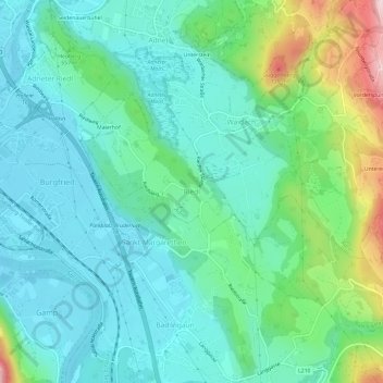
Name: Riedl topographic map, elevation, terrain.
Location: Riedl, Adnet, Bezirk Hallein, Salzburg, 5421, Austria (47.66051 13.11593 47.70051 13.15593)
Average elevation: 522 m
Minimum elevation: 442 m
Maximum elevation: 783 m
Make a donation
Gear up for your next adventure:
As an Amazon Associate, this site earns from qualifying purchases at no extra cost to you.
Other topographic maps
Click on a map to view its topography, its elevation and its terrain.
Salzburg Slate Alps
Austria > Salzburg > Bezirk Hallein
From a topographic perspective there are two subgroups, separated by the Salzach river where it bends northwards near St Johann im Pongau.
Average elevation: 1,412 m
Make a donation
Gear up for your next adventure:
As an Amazon Associate, this site earns from qualifying purchases at no extra cost to you.
Golling an der Salzach
Austria > Salzburg > Bezirk Hallein > Golling an der Salzach
Average elevation: 1,234 m