
Make a donation
Gear up for your next adventure:
As an Amazon Associate, this site earns from qualifying purchases at no extra cost to you.
Kuchl topographic map
Click on the map to display elevation.
Make a donation
Gear up for your next adventure:
As an Amazon Associate, this site earns from qualifying purchases at no extra cost to you.
About this map
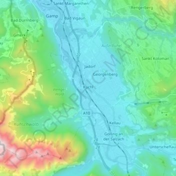
Name: Kuchl topographic map, elevation, terrain.
Location: Kuchl, Bezirk Hallein, Salzburg, 5431, Austria (47.58385 13.06262 47.66668 13.21657)
Average elevation: 826 m
Minimum elevation: 442 m
Maximum elevation: 2,476 m
Make a donation
Gear up for your next adventure:
As an Amazon Associate, this site earns from qualifying purchases at no extra cost to you.
Other topographic maps
Click on a map to view its topography, its elevation and its terrain.
Alpendorf Dachstein West
Austria > Salzburg > Bezirk Hallein > Annaberg-Lungötz > Annaberg im Lammertal
Average elevation: 1,047 m
Make a donation
Gear up for your next adventure:
As an Amazon Associate, this site earns from qualifying purchases at no extra cost to you.