
Make a donation
Gear up for your next adventure:
As an Amazon Associate, this site earns from qualifying purchases at no extra cost to you.
Belchamp St. Paul topographic map
Click on the map to display elevation.
Make a donation
Gear up for your next adventure:
As an Amazon Associate, this site earns from qualifying purchases at no extra cost to you.
About this map
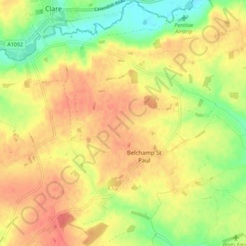
Name: Belchamp St. Paul topographic map, elevation, terrain.
Location: Belchamp St. Paul, Braintree, Essex, England, United Kingdom (52.03248 0.56825 52.08091 0.64145)
Average elevation: 68 m
Minimum elevation: 38 m
Maximum elevation: 90 m
Essex trails, hiking, mountain biking, running and outdoor activities
Make a donation
Gear up for your next adventure:
As an Amazon Associate, this site earns from qualifying purchases at no extra cost to you.
Other topographic maps
Click on a map to view its topography, its elevation and its terrain.
Make a donation
Gear up for your next adventure:
As an Amazon Associate, this site earns from qualifying purchases at no extra cost to you.
Hedingham Castle
United Kingdom > England > Essex > Braintree > Castle Hedingham
Average elevation: 67 m
Make a donation
Gear up for your next adventure:
As an Amazon Associate, this site earns from qualifying purchases at no extra cost to you.