
Make a donation
Gear up for your next adventure:
As an Amazon Associate, this site earns from qualifying purchases at no extra cost to you.
Great Saling topographic map
Click on the map to display elevation.
Make a donation
Gear up for your next adventure:
As an Amazon Associate, this site earns from qualifying purchases at no extra cost to you.
About this map
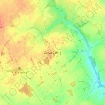
Name: Great Saling topographic map, elevation, terrain.
Location: Great Saling, Braintree, Essex, England, CM7 5FS, United Kingdom (51.88191 0.45336 51.92191 0.49336)
Average elevation: 80 m
Minimum elevation: 57 m
Maximum elevation: 98 m
Essex trails, hiking, mountain biking, running and outdoor activities
Make a donation
Gear up for your next adventure:
As an Amazon Associate, this site earns from qualifying purchases at no extra cost to you.
Other topographic maps
Click on a map to view its topography, its elevation and its terrain.
Hedingham Castle
United Kingdom > England > Essex > Braintree > Castle Hedingham
Average elevation: 67 m
Helions Bumpstead
United Kingdom > England > Essex > Braintree > Helions Bumpstead
Average elevation: 102 m
Make a donation
Gear up for your next adventure:
As an Amazon Associate, this site earns from qualifying purchases at no extra cost to you.
Great Maplestead
United Kingdom > England > Essex > Braintree > Great Maplestead
Average elevation: 66 m
Make a donation
Gear up for your next adventure:
As an Amazon Associate, this site earns from qualifying purchases at no extra cost to you.
Make a donation
Gear up for your next adventure:
As an Amazon Associate, this site earns from qualifying purchases at no extra cost to you.
Tilbury Juxta Clare
United Kingdom > England > Essex > Braintree > Tilbury juxta Clare
Average elevation: 77 m
Make a donation
Gear up for your next adventure:
As an Amazon Associate, this site earns from qualifying purchases at no extra cost to you.
Make a donation
Gear up for your next adventure:
As an Amazon Associate, this site earns from qualifying purchases at no extra cost to you.