
Mandaluyong topographic map
Interactive map
Click on the map to display elevation.
About this map
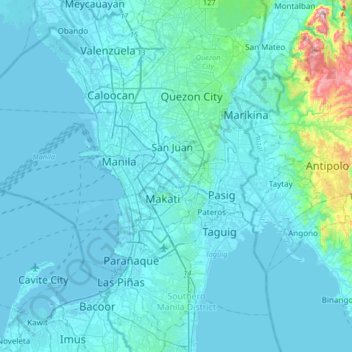
Name: Mandaluyong topographic map, elevation, terrain.
Location: Mandaluyong, Metro Manila, 1551, Philippines (14.41778 120.87323 14.73778 121.19323)
Average elevation: 33 m
Minimum elevation: -3 m
Maximum elevation: 457 m
Another claims that the Spaniards named the place based on the report of a navigator named Acapulco, who saw the rolling hills frequently being lashed at by daluyong (“big waves from the sea”). This seems to confirm traditional pre-Hispanic stories that giant waves from the sea would meet the adjoining hills of the vast lowland, referred to as salpukan ng alon. Felix dela Huerta, a Franciscan historian, observed that the rolling topography of this land resembled giant waves of the sea. As with the etymological legends of many Philippine places, when the foreigners asked as to what the place was called, the locals answered with the description "madaluyong" ("undulating"), later transcribed by Spanish writers into "Mandaluyong" with the addition of an “n”.
Other topographic maps
Click on a map to view its topography, its elevation and its terrain.
Pasig River
Pasig River, District I, Mandaluyong, Eastern Manila District, Metro Manila, 1210, Philippines
Average elevation: 14 m
Barangka Drive
Barangka Drive, Mandaluyong, Second District, Metro Manila, Philippines
Average elevation: 17 m
New Zañiga
New Zañiga, Mandaluyong, Metro Manila, Philippines
Average elevation: 11 m