
Van topographic map
Interactive map
Click on the map to display elevation.
About this map
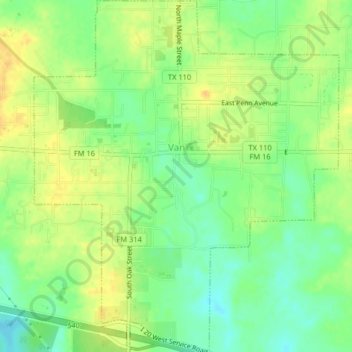
Name: Van topographic map, elevation, terrain.
Location: Van, Van Zandt County, Texas, 75790, United States (32.50500 -95.65415 32.53915 -95.61904)
Average elevation: 152 m
Minimum elevation: 136 m
Maximum elevation: 165 m
Other topographic maps
Click on a map to view its topography, its elevation and its terrain.
Martins Mill
United States > Texas > Van Zandt County
Martins Mill, Van Zandt County, Texas, United States
Average elevation: 157 m
Canton
United States > Texas > Van Zandt County
Canton, Van Zandt County, Texas, 75103, United States
Average elevation: 159 m