
Martins Mill topographic map
Interactive map
Click on the map to display elevation.
About this map
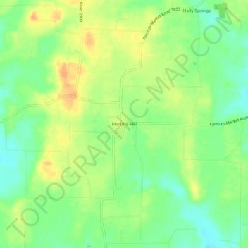
Name: Martins Mill topographic map, elevation, terrain.
Location: Martins Mill, Van Zandt County, Texas, United States (32.39625 -95.81024 32.43625 -95.77024)
Average elevation: 157 m
Minimum elevation: 138 m
Maximum elevation: 177 m
Other topographic maps
Click on a map to view its topography, its elevation and its terrain.
Wills Point
United States > Texas > Van Zandt County
Founded in 1873, Wills Point derives its name from an early American settler, William Wills, who had arrived in the area circa 1848. Wills eventually purchased a cabin from Adam Sullivan in 1852. The name 'point' may also derive from the shape of the original timberline near the cabin, though there have been…
Average elevation: 155 m