
Fort Selkirk topographic map
Interactive map
Click on the map to display elevation.
About this map
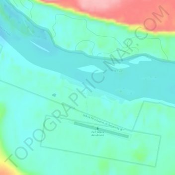
Name: Fort Selkirk topographic map, elevation, terrain.
Location: Fort Selkirk, Yukon, Kanada (62.76522 -137.39682 62.78522 -137.37682)
Average elevation: 448 m
Minimum elevation: 420 m
Maximum elevation: 547 m
Other topographic maps
Click on a map to view its topography, its elevation and its terrain.
Tombstone Territorial Park
Tombstone Territorial Park, Yukon, Kanada
Average elevation: 1,546 m
Destruction Bay
Kanada > Yukon > Destruction Bay > Destruction Bay
Destruction Bay, Yukon, Unorganized, Yukon, Y0B 1H0, Kanada
Average elevation: 893 m