Geolocate

Rayap topographic map

Click on the map to display elevation.

About this map

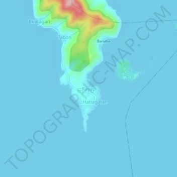
Name: Rayap topographic map, elevation, terrain.

Location: Rayap, Binangonan, Rizal, Calabarzon, 1940, Philippines (14.27681 121.21774 14.31681 121.25774)

Average elevation: 14 m

Minimum elevation: -5 m

Maximum elevation: 249 m

Other topographic maps

Click on a map to view its topography, its elevation and its terrain.

Libis

Philippines > Rizal > Binangonan

Average elevation: 10 m

Calumpang

Philippines > Rizal > Binangonan > Macamot

Average elevation: 16 m

Talim

Philippines > Rizal > Binangonan

Average elevation: 13 m

Gear up for your next adventure:

🧤Thermal Touchscreen Gloves - Stay warm while operating your GPS or smartphone camera
🔋Solar Chargers - Eco-friendly charging solutions for outdoor use
🧣Fleece Neck Warmers - Extra insulation for winter topographic surveys
🍱Food Containers - Reusable containers for outdoor meals
🧺Mesh Stuff Sacks - Breathable storage for wet gear or camp organization

As an Amazon Associate, this site earns from qualifying purchases at no extra cost to you.