Geolocate

Gaojiazhuang topographic map

Interactive map

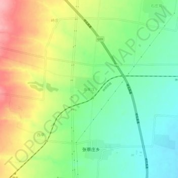
Click on the map to display elevation.

About this map

Name: Gaojiazhuang topographic map, elevation, terrain.

Location: Gaojiazhuang, Shuocheng District, Shuozhou City, Shanxi, China (39.28148 112.30651 39.32148 112.34651)

Average elevation: 1,183 m

Minimum elevation: 1,132 m

Maximum elevation: 1,258 m

Other topographic maps

Click on a map to view its topography, its elevation and its terrain.

Houma City

China > Shanxi

Average elevation: 493 m

Xinzhou

China > Shanxi

Average elevation: 1,311 m

Dongchengjie Subdistrict

China > Shanxi > Gaoping City

Average elevation: 893 m

Yushe County

China > Shanxi > Jinzhong

Average elevation: 1,244 m

Pingcheng District

China > Shanxi

Average elevation: 1,099 m

Yangquan

China > Shanxi

Average elevation: 920 m

Fenyang City

China > Shanxi

Average elevation: 1,075 m

Yuncheng

China > Shanxi

Average elevation: 688 m

Gaoping City

China > Shanxi

Average elevation: 985 m

Lin County

China > Shanxi

Average elevation: 1,167 m

Wangqiao

China > Shanxi > Xiangyuan County

Average elevation: 960 m

Pingyao County

China > Shanxi > Jinzhong

Average elevation: 1,128 m

Yungang

China > Shanxi > Datong

Average elevation: 1,189 m

Hunyuan County

China > Shanxi > Datong

Average elevation: 1,455 m

Hejin City

China > Shanxi

Average elevation: 570 m

Xiangfen County

China > Shanxi

Average elevation: 614 m

Tianzhen County

China > Shanxi

Average elevation: 1,239 m

Shuozhou City

China > Shanxi

Average elevation: 1,367 m

Taiyuan

China > Shanxi

Average elevation: 1,195 m

Lan County

China > Shanxi

Average elevation: 1,518 m

Datong

China > Shanxi

Average elevation: 1,339 m

Pu County

China > Shanxi

Average elevation: 1,267 m

Yungang District

China > Shanxi > Datong

Average elevation: 1,186 m

Youyu County

China > Shanxi

Elevations are generally higher in the south of the county, in which flows the Cangtou River (苍头河); Youyu reaches a north-south extent of 67.7 km (42.1 mi) and east-west width of 45.7 km (28.4 mi). The Great Wall demarcates the northwestern border with Inner Mongolia's Liangcheng and Horinger counties;…

Average elevation: 1,486 m

Lingqiu County

China > Shanxi > Datong

Average elevation: 1,250 m

Guangling County

China > Shanxi > Datong City

Average elevation: 1,424 m

Taiyuan

China > Shanxi

Taiyuan experiences a cold semi-arid climate (Köppen climate classification BSk). Taiyuan has a temperate monsoon climate.Spring is dry, with occasional dust storms, followed by early summer heat waves. Summer tends to be warm to hot with most of the year's rainfall concentrated in July and August. Winter is…

Average elevation: 1,195 m

Taigu County

China > Shanxi > Taigu County > Jinzhong City

Average elevation: 1,098 m

Linyi County

China > Shanxi

Average elevation: 464 m

Jinzhong

China > Shanxi

Average elevation: 1,121 m

Datong

China > Shanxi

Datong is a prefecture-level city in northern Shanxi Province in the People's Republic of China. It is located in the Datong Basin at an elevation of 1,040 metres (3,410 ft) and borders Inner Mongolia to the north and west and Hebei to the east. As of the 2020 census, it had a population of 3,105,591 of whom…

Average elevation: 1,339 m

Taiyuan

China > Shanxi

Taiyuan experiences a cold semi-arid climate (Köppen climate classification BSk). Taiyuan has a temperate monsoon climate.Spring is dry, with occasional dust storms, followed by early summer heat waves. Summer tends to be warm to hot with most of the year's rainfall concentrated in July and August. Winter is…

Average elevation: 1,195 m

Datong

China > Shanxi

Datong is a prefecture-level city in northern Shanxi Province in the People's Republic of China. It is located in the Datong Basin at an elevation of 1,040 metres (3,410 ft) and borders Inner Mongolia to the north and west and Hebei to the east. As of the 2020 census, it had a population of 3,105,591 of whom…

Average elevation: 1,339 m

Jinzhong

China > Shanxi

Average elevation: 1,121 m

Xing County

China > Shanxi > Xing County

Average elevation: 1,246 m