
Saint Croix River topographic map
Interactive map
Click on the map to display elevation.
About this map
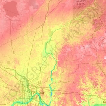
Name: Saint Croix River topographic map, elevation, terrain.
Average elevation: 322 m
Minimum elevation: 204 m
Maximum elevation: 494 m
Other topographic maps
Click on a map to view its topography, its elevation and its terrain.
Sturgeon Lake
USA > Minnesota > Sturgeon Lake
Sturgeon Lake, Pine County, Minnesota, 55783, USA
Average elevation: 325 m
Kettle River
Kettle River, Carlton County, Minnesota, 55757, USA
Average elevation: 367 m
Credit River
Credit River, Savage, Scott County, Minnesota, 55378, USA
Average elevation: 224 m
Maplewood State Park
Maplewood State Park, Otter Tail County, Minnesota, USA
Average elevation: 429 m
Hiawatha
USA > Minnesota > Minneapolis
Hiawatha, Minneapolis, Hennepin County, Minnesota, USA
Average elevation: 249 m
Pelican Rapids
USA > Minnesota > Pelican Rapids
Pelican Rapids, Otter Tail County, Minnesota, USA
Average elevation: 405 m
Cathedral Hill Park
USA > Minnesota > Saint Paul
Cathedral Hill Park, Saint Paul, Ramsey County, Minnesota, USA
Average elevation: 252 m
Old Mill State Park
Old Mill State Park, Foldahl, Marshall County, Minnesota, USA
Average elevation: 299 m
Burrows Lake
Burrows Lake, North Burrows Lake Road, Itasca County, Minnesota, USA
Average elevation: 426 m
Buckshot Lake
Buckshot Lake, Portage, Cook County, Minnesota, USA
Average elevation: 593 m
Smith Lake
USA > Minnesota > Smith Lake
Smith Lake, Wright County, Minnesota, USA
Average elevation: 319 m
Hjalmer Lake
Hjalmer Lake, Nelson Road, Toimi, Lake County, Minnesota, USA
Average elevation: 550 m
Armstrong River
Armstrong River, Saint Louis County, Minnesota, USA
Average elevation: 432 m
William Lake
William Lake, County Road 94, Todd County, Minnesota, 56378, USA
Average elevation: 400 m
Clearwater River
Clearwater River, Meeker County, Minnesota, 55389, USA
Average elevation: 353 m
Alexandria
USA > Minnesota > Alexandria
Alexandria, Douglas County, Minnesota, 56308, USA
Average elevation: 426 m
Bennett Lake
Bennett Lake, County Road C, Roseville, Ramsey County, Minnesota, 55113, USA
Average elevation: 282 m
Carley State Park
Carley State Park, Wabasha County, Minnesota, USA
Average elevation: 331 m
Buffalo Lake
USA > Minnesota > Buffalo Lake
Buffalo Lake, Renville County, Minnesota, USA
Average elevation: 325 m
Stewart River
Stewart River, Lake County, Minnesota, 55616, USA
Average elevation: 335 m
Wenonah
USA > Minnesota > Minneapolis
Wenonah, Minneapolis, Hennepin County, Minnesota, USA
Average elevation: 255 m
Gervais Lake
USA > Minnesota > Little Canada
Gervais Lake, Carla Lane, Little Canada, Ramsey County, Minnesota, 55109, USA
Average elevation: 271 m
Island Lake
USA > Minnesota > Island Lake
Island Lake, Beltrami County, Minnesota, USA
Average elevation: 408 m
Johnson River
Johnson River, Saint Louis County, Minnesota, USA
Average elevation: 382 m
Black Duck River
Black Duck River, Saint Louis County, Minnesota, USA
Average elevation: 422 m
Little Mississippi River
Little Mississippi River, Clearwater County, Minnesota, USA
Average elevation: 439 m
Green Water Lake
Green Water Lake, County Highway 35, Pine Point, Becker County, Minnesota, 56575, USA
Average elevation: 481 m