
Angono topographic map
Click on the map to display elevation.
About this map
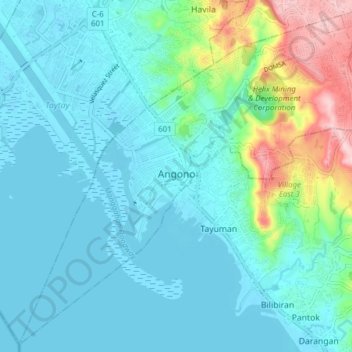
Name: Angono topographic map, elevation, terrain.
Location: Angono, Rizal, Calabarzon, 1930, Philippines (14.48945 121.11835 14.56127 121.19567)
Average elevation: 43 m
Minimum elevation: -3 m
Maximum elevation: 235 m
Other topographic maps
Click on a map to view its topography, its elevation and its terrain.
Antipolo
Its higher elevation than that of Metro Manila affords it a scenic view of the metropolis, especially at night. Its locally grown mangoes and cashews are popular among tourists, as well as suman – a local delicacy made out of glutinous rice. The Hinulugang Taktak National Park, which was once a popular…
Average elevation: 125 m
Montalban
Philippines > Rizal > Rodriguez
Rodriguez is generally very rough in topography, with 83% of its total land area composed of upland areas, hills and mountain ranges. The remaining 17% low-lying terrain and rolling lands are found at the south-western portion of the municipality, along with the northern portions of the Municipality of San…
Average elevation: 99 m
San Mateo
Philippines > Rizal > San Mateo
The main source of the municipality's water supply are deep wells, pump wells (operated by Manila Water), open wells, springs and other ground water resources. Some of the elevated parts of the municipality are under watershed protected areas since the topography is characterized by rolling to mountainous…
Average elevation: 68 m