Geolocate

Katwijk topographic map

Click on the map to display elevation.

About this map

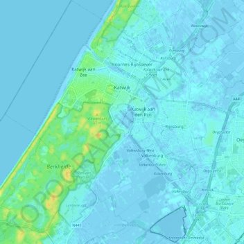
Name: Katwijk topographic map, elevation, terrain.

Location: Katwijk, South Holland, Netherlands (52.15565 4.36000 52.22524 4.46652)

Average elevation: 3 m

Minimum elevation: -4 m

Maximum elevation: 25 m

Other topographic maps

Click on a map to view its topography, its elevation and its terrain.

Langeraar

Netherlands > South Holland

Average elevation: -3 m

Ankerpark

Netherlands > South Holland > Leiden

Average elevation: 3 m

Weerestein

Netherlands > South Holland > Hillegom

Average elevation: 0 m

Weerestein

Netherlands > South Holland > Hillegom

Average elevation: 0 m

Broekhuizen

Netherlands > South Holland > Gouda

Average elevation: -1 m

Middelsluis

Netherlands > South Holland > Numansdorp

Average elevation: 0 m

Meije

Netherlands > South Holland > Nieuwkoop

Average elevation: -2 m

Botlek

Netherlands > South Holland

Average elevation: 3 m

Meijendel

Netherlands > South Holland > Wassenaar

Average elevation: 6 m

Coepelduynen

Netherlands > South Holland > Katwijk

Average elevation: 4 m

Het Park

Netherlands > South Holland > Rotterdam

Average elevation: 4 m

Waalhaven

Netherlands > South Holland > Rotterdam

Average elevation: 3 m

Gear up for your next adventure:

🧥Packable Down Jackets - Lightweight warmth that compresses small in your bag
🎒Hiking Daypacks (20L) - Compact backpacks for day trips and technical mountain ascents
🎒Hiking Backpacks - Comfortable backpacks for day hikes and multi-day treks
📍Handheld GPS Navigators - Reliable satellite navigation for hiking and off-road exploration
👕Merino Base Layers - Natural temperature regulation for cold weather hiking and camping

As an Amazon Associate, this site earns from qualifying purchases at no extra cost to you.