Geolocate

Langeraar topographic map

Click on the map to display elevation.

About this map

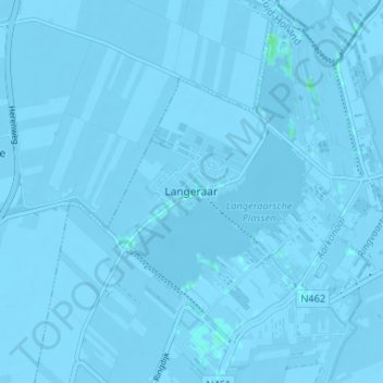
Name: Langeraar topographic map, elevation, terrain.

Location: Langeraar, Ter Aar, Nieuwkoop, South Holland, Netherlands, 2461 RW, Netherlands (52.17318 4.68973 52.21318 4.72973)

Average elevation: -3 m

Minimum elevation: -7 m

Maximum elevation: 4 m

Other topographic maps

Click on a map to view its topography, its elevation and its terrain.

Rotterdam

Netherlands > South Holland

Average elevation: 0 m

The Hague

Netherlands > South Holland

Average elevation: 2 m

Delft

Netherlands > South Holland > Delft

Average elevation: 0 m

The Hague

Netherlands > South Holland

Average elevation: 2 m

The Hague

Netherlands > South Holland

Average elevation: 2 m

Noordeloos

Netherlands > South Holland

Average elevation: -1 m

Rotterdam

Netherlands > South Holland

Average elevation: 0 m

Sliedrecht

Netherlands > South Holland

Dutch topographic map of the municipality of Sliedrecht, June 2015

Average elevation: 0 m

Ouddorp

Netherlands > South Holland

Average elevation: 0 m

Dordrecht

Netherlands > South Holland

Average elevation: 1 m

Hellevoetsluis

Netherlands > South Holland

Average elevation: 0 m

Meijendel

Netherlands > South Holland > Wassenaar

Average elevation: 5 m

Rotterdam

Netherlands > South Holland

Average elevation: 0 m

The Hague

Netherlands > South Holland

Average elevation: 2 m

Pernis

Netherlands > South Holland

Average elevation: 3 m

Pernis

Netherlands > South Holland

Average elevation: 3 m

Rotterdam

Netherlands > South Holland

Average elevation: 0 m

Ankerpark

Netherlands > South Holland > Leiden

Average elevation: 3 m

Noordwijkerhout

Netherlands > South Holland > Noordwijk

Dutch topographic map of the municipality of Noordwijkerhout, June 2015

Average elevation: 2 m

Katwijk

Netherlands > South Holland

Average elevation: 3 m

The Hague

Netherlands > South Holland

Average elevation: 2 m

Bergschenhoek

Netherlands > South Holland

Average elevation: -4 m

Katwijk

Netherlands > South Holland

Average elevation: 3 m

Voorburg

Netherlands > South Holland

Average elevation: 3 m

The Hague

Netherlands > South Holland

Average elevation: 2 m

Spijkenisse

Netherlands > South Holland

Average elevation: 1 m

Dordrecht

Netherlands > South Holland

Average elevation: 1 m

Lisse

Netherlands > South Holland > Lisse

Average elevation: -1 m

The Hague

Netherlands > South Holland

Average elevation: 2 m

The Hague

Netherlands > South Holland

Average elevation: 2 m

Zoetermeer

Netherlands > South Holland > Zoetermeer

Average elevation: -3 m

Schoonhoven

Netherlands > South Holland

Average elevation: 0 m

The Hague

Netherlands > South Holland

Average elevation: 2 m

Hillegom

Netherlands > South Holland

Average elevation: -1 m

Dordrecht

Netherlands > South Holland

Average elevation: 1 m

Vlaardingen

Netherlands > South Holland > Vlaardingen

Average elevation: 1 m

Gorinchem

Netherlands > South Holland

Average elevation: 1 m

Rotterdam

Netherlands > South Holland

Average elevation: 0 m

Barendrecht

Netherlands > South Holland

Average elevation: 1 m

Barendrecht

Netherlands > South Holland > Barendrecht

Average elevation: 1 m

Spijkenisse

Netherlands > South Holland

Average elevation: 1 m

Leiden

Netherlands > South Holland

Average elevation: 1 m

Wassenaar

Netherlands > South Holland > Wassenaar

Average elevation: 3 m

Oostvoorne

Netherlands > South Holland

Average elevation: 2 m

Europoort

Netherlands > South Holland

Average elevation: 2 m

Katwijk

Netherlands > South Holland

Average elevation: 3 m

Wassenaar

Netherlands > South Holland > Wassenaar

Average elevation: 3 m

Voorschoten

Netherlands > South Holland

Average elevation: 1 m

Meije

Netherlands > South Holland > Nieuwkoop

Average elevation: -2 m

Leiden

Netherlands > South Holland

Average elevation: 1 m

Piershil

Netherlands > South Holland

Average elevation: 0 m

Rijswijk

Netherlands > South Holland

Average elevation: 2 m

Zuidplas

Netherlands > South Holland

Dutch Topographic map of the municipality of Zuidplas, September 2014

Average elevation: -3 m

Gouda

Netherlands > South Holland

Average elevation: -1 m

Teylingen

Netherlands > South Holland

Average elevation: 0 m

Monster

Netherlands > South Holland

Average elevation: 1 m

Heenvliet

Netherlands > South Holland

Average elevation: 1 m

Naaldwijk

Netherlands > South Holland

Average elevation: 1 m

Ouddorp

Netherlands > South Holland

Average elevation: 0 m

Delft

Netherlands > South Holland

Average elevation: 0 m

Spijkenisse

Netherlands > South Holland

Average elevation: 1 m

Leiden

Netherlands > South Holland

Average elevation: 1 m

Wassenaar

Netherlands > South Holland

Average elevation: 3 m

The Hague

Netherlands > South Holland

Average elevation: 2 m

Rotterdam

Netherlands > South Holland

Average elevation: 0 m

Bleiswijk

Netherlands > South Holland

Average elevation: -4 m

Numansdorp

Netherlands > South Holland

Average elevation: 0 m

Delft

Netherlands > South Holland > Delft

Average elevation: 0 m

Nootdorp

Netherlands > South Holland

Average elevation: -2 m

Papendrecht

Netherlands > South Holland

Average elevation: 2 m

Sliedrecht

Netherlands > South Holland

Dutch topographic map of the municipality of Sliedrecht, June 2015

Average elevation: 0 m

Berkenwoude

Netherlands > South Holland

Average elevation: -1 m

Delfgauw

Netherlands > South Holland

Average elevation: -1 m

Schiedam

Netherlands > South Holland

Average elevation: 1 m

Capelle aan den IJssel

Netherlands > South Holland

Dutch Topographic map of the municipality of Capelle aan den IJssel, June 2015.

Average elevation: -1 m

Maassluis

Netherlands > South Holland > Maassluis

Average elevation: 2 m

Noordwijk

Netherlands > South Holland

Average elevation: 1 m

Berkenwoude

Netherlands > South Holland

Average elevation: -1 m

Waddinxveen

Netherlands > South Holland

Average elevation: -3 m

Botlek

Netherlands > South Holland

Average elevation: 3 m

Zwijndrecht

Netherlands > South Holland

Average elevation: 1 m

Hendrik-Ido-Ambacht

Netherlands > South Holland > Hendrik-Ido-Ambacht

Dutch topographic map of the municipality of Hendrik-Ido-Ambacht, June 2015

Average elevation: 1 m

Naaldwijk

Netherlands > South Holland

Average elevation: 1 m

Zwijndrecht

Netherlands > South Holland

Average elevation: 1 m

Rotterdam

Netherlands > South Holland

Average elevation: 0 m

Streefkerk

Netherlands > South Holland

Average elevation: -1 m

Monster

Netherlands > South Holland

Average elevation: 1 m

Delft

Netherlands > South Holland

Average elevation: 0 m

The Hague

Netherlands > South Holland

Average elevation: 2 m

Leiden

Netherlands > South Holland

Average elevation: 1 m

Gorinchem

Netherlands > South Holland

Average elevation: 1 m

Rotterdam

Netherlands > South Holland

Average elevation: 0 m

Kinderdijk

Netherlands > South Holland

Average elevation: 1 m

Gear up for your next adventure:

🎒Hiking Daypacks - Compact backpacks ideal for short hikes and excursions
🛌Insulated Sleeping Mats - Crucial thermal protection when sleeping on cold, uneven ground
🎒Multi-day Trekking Packs - Large capacity backpacks for wild camping and long-distance trails
🔋Rechargeable Batteries - Eco-friendly power for headlamps and older GPS units
🔋Lithium AA Batteries - Long-lasting power that performs well in cold mountain weather

As an Amazon Associate, this site earns from qualifying purchases at no extra cost to you.