Geolocate

Delft topographic map

Click on the map to display elevation.

About this map

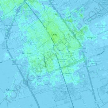
Name: Delft topographic map, elevation, terrain.

Location: Delft, South Holland, Netherlands (51.96632 4.32022 52.03260 4.40791)

Average elevation: 0 m

Minimum elevation: -6 m

Maximum elevation: 6 m

Other topographic maps

Click on a map to view its topography, its elevation and its terrain.

Langeraar

Netherlands > South Holland

Average elevation: -3 m

Broekhuizen

Netherlands > South Holland > Gouda

Average elevation: -1 m

Ankerpark

Netherlands > South Holland > Leiden

Average elevation: 3 m

Botlek

Netherlands > South Holland

Average elevation: 3 m

Middelsluis

Netherlands > South Holland > Numansdorp

Average elevation: 0 m

Meije

Netherlands > South Holland > Nieuwkoop

Average elevation: -2 m

Weerestein

Netherlands > South Holland > Hillegom

Average elevation: 0 m

Weerestein

Netherlands > South Holland > Hillegom

Average elevation: 0 m

Meijendel

Netherlands > South Holland > Wassenaar

Average elevation: 6 m

Coepelduynen

Netherlands > South Holland > Katwijk

Average elevation: 4 m

Het Park

Netherlands > South Holland > Rotterdam

Average elevation: 4 m

Waalhaven

Netherlands > South Holland > Rotterdam

Average elevation: 3 m

Gear up for your next adventure:

🥾Men's Waterproof Hiking Boots - Durable footwear with deep lugs for muddy and rocky UK terrains
💧Hydration Reservoirs - Convenient water bladders for hands-free drinking on the move
❄️Walking Crampons - Added traction for icy slopes and winter peak bagging
🔦Waterproof LED Headlamps - Hands-free lighting for evening treks and emergency navigation
👟Men's Trail Running Shoes - Lightweight grip for fast movement over topographic contours

As an Amazon Associate, this site earns from qualifying purchases at no extra cost to you.