Geolocate

Leiden topographic map

Click on the map to display elevation.

About this map

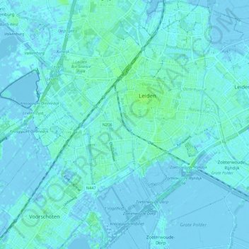
Name: Leiden topographic map, elevation, terrain.

Location: Leiden, South Holland, Netherlands (52.11895 4.43887 52.18463 4.52407)

Average elevation: 1 m

Minimum elevation: -5 m

Maximum elevation: 7 m

Other topographic maps

Click on a map to view its topography, its elevation and its terrain.

Langeraar

Netherlands > South Holland

Average elevation: -3 m

Broekhuizen

Netherlands > South Holland > Gouda

Average elevation: -1 m

Ankerpark

Netherlands > South Holland > Leiden

Average elevation: 3 m

Middelsluis

Netherlands > South Holland > Numansdorp

Average elevation: 0 m

Meije

Netherlands > South Holland > Nieuwkoop

Average elevation: -2 m

Weerestein

Netherlands > South Holland > Hillegom

Average elevation: 0 m

Weerestein

Netherlands > South Holland > Hillegom

Average elevation: 0 m

Botlek

Netherlands > South Holland

Average elevation: 3 m

Meijendel

Netherlands > South Holland > Wassenaar

Average elevation: 6 m

Coepelduynen

Netherlands > South Holland > Katwijk

Average elevation: 4 m

Het Park

Netherlands > South Holland > Rotterdam

Average elevation: 4 m

Waalhaven

Netherlands > South Holland > Rotterdam

Average elevation: 3 m

Gear up for your next adventure:

🛰️Outdoor GPS Navigation - Navigation devices for remote and off-grid areas
🔦Outdoor Torches - Reliable torches for night navigation
🍱Food Containers - Reusable containers for outdoor meals
📻Hand-Crank Emergency Radios - Stay updated on weather warnings in remote areas
📢Survival Whistles - Essential safety gear for signaling for help in mountain fog

As an Amazon Associate, this site earns from qualifying purchases at no extra cost to you.